The totality of the unevenness of the earth's surface forms it relief. Landforms vary in size, origin, and development history. The relief of the earth, or more correctly, the earth's surface, is the result of a complex interaction of internal and external forces. Internal forces, the energy of which is provided by the internal energy of the Earth itself, create large irregularities. External forces smooth out these irregularities, creating smaller irregularities.
The largest landforms of the Earth- ridges of continents and depressions of oceans. Their distribution is determined by the structure of the earth's crust - the presence or absence of a granite layer. There are currently six continents on Earth. Land on the Earth's surface is distributed unevenly. We can distinguish two conventional hemispheres on the planet - oceanic and continental. In the center of the first is the Pacific Ocean, in the center of the second is Africa. The prevailing heights within the land are about 800 m, the average depths of the ocean are about 3500 m. The surface of the land and the ocean bottom is complicated by lower-order irregularities.
The main landforms are mountains and plains. About 60% of the land surface is occupied plains. These are vast areas of the earth's surface with small fluctuations in heights (about 200 m), relatively low elevated above sea level. Based on absolute height, the plains are divided on lowlands (height from 0 to 200 m), hills (200-500 m) and plateaus (above 500 m). By the nature of the surface- flat, hilly and stepped. Lowland areas are the most populated and developed by people. Most cities and transport routes and the main tracts of cultivated land are concentrated on them.
They call them mountains distinct elevations on the earth's surface with heights of more than 200 m, with well-defined slopes and bases. Mountainous regions occupy about 40% of the land surface. Most of the mountains on Earth stretch in mutually perpendicular directions, close to sublatitudinal or submeridional. By height, mountains are divided into low (with altitudes up to 1000 m), medium-altitude (1000-2000 m) and high (over 2000 m). According to the structure of mountains there are folded, folded - blocky and blocky. According to geomorphological age, they are distinguished young, rejuvenated and reborn mountains. Mountains of tectonic origin predominate on land, while mountains of volcanic origin predominate in the oceans.

Within the land, the distribution of mountainous and lowland areas is determined by the structure of the earth's crust. On the platforms, due to the horizontal occurrence of rocks, there are plains. In folded areas, rocks occur in the form of folds, and in the relief they correspond to mountains.
The structure of the earth's crust determines not only the relief, but also the placement of mineral resources. Minerals of sedimentary origin (oil, gas, coal, salts) are concentrated in the sedimentary rocks of the platform cover. Minerals of igneous origin - in folded areas and crystalline platform basements. The greatest variety of minerals is characteristic of ancient platforms.
Still have questions? Want to know more about the topography of the earth's surface?Register.
The first lesson is free!
website, when copying material in full or in part, a link to the original source is required.
When studying geography and topography, we come across such a concept as terrain. What is this term and what is it used for? In this article we will understand the meaning of this word, find out what types there are and much more.
Concept of relief
So what does this term mean? Relief is a set of irregularities on the surface of our planet, which are made up of elementary forms. There is even a separate science that studies its origin, history of development, dynamics and internal structure. It's called geomorphology. The relief consists of individual forms, that is, natural bodies that represent its individual parts and have their own dimensions.
Variety of shapes
According to the morphological principle of classification, these can be both positive and negative. The first of them rise above the horizon, representing a rise in the surface. Examples include a hillock, a hill, a plateau, a mountain, etc. The latter, accordingly, form a depression relative to the horizon line. These can be valleys, beams, depressions, ravines, etc. As mentioned above, the shape of the relief is composed of individual elements: surfaces (edges), points, lines (edges), corners. According to the degree of complexity, complex and simple natural bodies are distinguished. Simple forms include mounds, hollows, hollows, etc. They are individual morphological elements, the combination of which forms a form. An example is a mound. It is divided into the following parts: bottom, slope, top. A complex form consists of a number of simple ones. For example, a valley. It includes the riverbed, floodplain, slopes, etc.

Based on the degree of slope, subhorizontal surfaces (less than 20 degrees), inclined surfaces and slopes (more than 20 degrees) are distinguished. They can have different shapes - straight, convex, concave or stepped. According to the degree of extension, they are usually divided into closed and open.
Types of reliefs
The combination of elementary forms that have a similar origin and extend over a certain space determines the type of relief. In large areas of our planet, it is possible to unite several individual species on the basis of similar origin or differences. In such cases, it is customary to talk about groups of relief types. When the association is made on the basis of their formation, they speak of genetic types of elementary forms. The most common types of land relief are flat and mountainous. Based on height, the former are usually divided into depressions, hills, lowlands, plateaus and plateaus. Among the latter, medium and low are distinguished.

Flat terrain
This is an area characterized by insignificant (up to 200 meters) relative elevations, as well as relatively low slopes (up to 5 degrees). The absolute heights here are small (only up to 500 meters). These areas (land, bottom of seas and oceans), depending on the absolute height, can be low (up to 200 meters), elevated (200-500 meters), mountainous or high (over 500 meters). The relief of the plains depends primarily on the degree of ruggedness and soil and vegetation cover. These can be loamy, clayey, peat, sandy loam soils. They can be cut by river beds, gullies and ravines.
Hilly terrain
A wavy formation of irregularities with absolute heights of up to 500 meters, relative elevations of up to 200 meters and a steepness of no more than 5 degrees. Hills are often made of hard rock, with the slopes and summits covered in a thick layer of loose rock. The lowlands between them are flat, wide or closed basins.
Hills
Mountainous terrain is an area that represents the surface of the planet, significantly elevated relative to the surrounding area. It is characterized by absolute heights of 500 meters. This territory is characterized by varied and complex terrain, as well as specific natural and weather conditions. The main forms are mountain ranges with characteristic steep slopes, which often turn into cliffs and rocks, as well as gorges and hollows located between the ridges. Mountainous areas of the earth's surface are significantly elevated above ocean level, while they have a common base that rises above the adjacent plains. They consist of many negative and positive landforms. According to the level of altitude, they are usually divided into low mountains (up to 800 meters), mid mountains (800-2000 meters) and high mountains (from 2000 meters).
Relief formation
The age of the elementary forms of the earth's surface can be relative and absolute. The first establishes the formation of relief relative to some other surface (earlier or later). The second is determined with the help of The relief is formed due to the constant interaction of exogenous and endogenous forces. Thus, endogenous processes are responsible for the formation of the main features of elementary forms, while exogenous processes, on the contrary, tend to align them. In relief formation, the main sources are the energy of the Earth and the Sun, and we should not forget about the influence of space. The formation of the earth's surface occurs under the influence of gravity. The main source of endogenous processes can be called the thermal energy of the planet, which is associated with radioactive decay occurring in its mantle. Thus, under the influence of these forces, the continental and oceanic crust was formed. Endogenous processes cause the formation of faults, folds, movement of the lithosphere, volcanism and earthquakes.

Geological observations
Geomorphologists study the shape of the surface of our planet. Their main task is to study the geological structure and terrain of specific countries, continents, and planets. When compiling a characteristic of a particular area, the observer is obliged to determine what caused the shape of the surface in front of him and to understand its origin. Of course, it will be difficult for a young geographer to understand these issues on his own, so it is better to turn to books or a teacher for help. When compiling a description of the relief, a group of geomorphologists is required to cross the study area. If you need to make a map only along the route of movement, then you should expand the observation band as much as possible. And during the research process, periodically move away from the main path to the sides. This is especially important for poorly visible areas, where forests or hills interfere with visibility.

Mapping
When recording information of a general nature (the terrain is hilly, mountainous, very rugged, etc.), it is also necessary to map and describe separately each element of the relief - a steep slope, ravine, ledge, river valley, etc. Determine dimensions - depth, width, height, angles of inclination - often it is necessary, as they say, by eye. Due to the fact that the relief depends on the geological structure of the area, when making observations, it is necessary to describe the geological structure, as well as the composition of the rocks that make up the surfaces being studied, and not just their appearance. It is necessary to mark in detail karst sinkholes, landslides, caves, etc. In addition to the description, schematic sketches of the study area should also be made.
Using this principle, you can explore the area near which your home is located, or you can describe the topography of the continents. The methodology is the same, only the scale is different, and it will take much more time to study the continent in detail. For example, in order to describe it, you will need to create many research groups, and even then this will take more than one year. After all, the mentioned continent is characterized by an abundance of mountains stretching along the entire continent, Amazonian virgin forests, Argentine pampas, etc., which creates additional difficulties.

Notes to the young geomorphologist
When drawing up a relief map of the area, it is recommended to ask local residents where you can observe the places where layers of rock and groundwater emerge. This data should be entered on the area map and described and sketched in detail. On the plains, rock is most often exposed in places where rivers or ravines have cut through the surface and formed coastal cliffs. These layers can also be observed in quarries or where a highway or railway passes through a cut-out excavation. The young geologist will have to examine and describe each layer of rock, starting from the bottom. Using a tape measure, you can make the necessary measurements, which should also be recorded in the field book. The description must indicate the dimensions and characteristics of each layer, their serial number and exact location.
If you look at school textbooks, you can see that children get their first idea of the types of relief in the elementary grades. This article will answer the question of what forms of relief exist in general, what causes them and what they represent.
Section 1. Definition of the concept
Relief types represent the most diverse forms of the surface of our planet: both low-lying and elevated, both simple and complex, both old and young. The word “relief” itself is of Latin origin, although in that once very widespread language, it was not a noun at all, but a verb, which could not be translated as “raise” or “raise.”
In most cases, relief refers to raised parts of the Earth's surface, such as hills and mountains. However, we should not forget about such important components of the landscape as lowlands, depressions and valleys. Few people, by the way, think about the fact that, in fact, some forms of relief are completely planetary in nature. Do you have any doubts? Then from what point of view should we consider such of them as continents or the ocean bed?
If we imagine a kind of diagram, which is based on the sizes of the elements surrounding us, then we will see that the rank below, after the continents and the ocean floor, can be placed depressions, mountain peaks and plains. Scientists also include intermountain depressions and ridges of mountain ranges as large forms.
Medium can be considered ravines, valleys and hills, and small or so-called microforms include insignificant flat depressions and gullies. And where, you ask, should we place such numerous cracks in the soil and hummocks in our area? To an even smaller form of organization, to nanoforms of relief.
Section 2. How did the main landforms arise?
We suggest looking at this issue from an unusual point of view. Let's imagine that the entire landscape of the Earth is the creation of an unknown master. Who can act as a “sculptor”? There were probably several of them, or rather two:
- The first actively influences from the outside. These include cosmic forces, namely solar and lunar gravity, as well as the force of rotation of the planet.
- The second prefers to change from the inside.
According to the point of view of modern scientists, all forms of relief necessarily bear the results of the influence of both internal and external forces. However, extensive types of lowlands, deep depressions and various kinds of ridges are created purely by tectonic (i.e. internal) forces of the planet. The outsiders, on the contrary, are making every possible effort to level the earth’s surface as quickly as possible and destroy the above-mentioned “buildings.” This is how the eternal struggle between two forces of opposite nature is waged on Earth, finding its imprint on our landscape.
Section 3. Landforms and their main types
The main types of earth's landscape include mountains (or hills), basins, ravines, saddles and ridges. Now let's look at each of them in more detail.
- A mountain is a cone-shaped hill. It is characterized by the presence of a top, side slopes, which are also called slopes, and a characteristic line of the sole.
- A hollow is something like a mountain, but it is directed not upward, but strictly downward. However, the cone-shaped shape is preserved, as are the side slopes. Instead of a sole, there is an edge, which connects the slopes of the basin with the surrounding terrain.
- The ridge can be considered a hill, the characteristic features of which include an elongated shape and its gradual decline in one direction.
- A hollow is an elongated shape, open at one end, representing a descending depression. The components of the hollow are considered to be the drainage line and two edge lines.
- And finally, a saddle should be understood as a relatively small depression that is observed between mountains located in close proximity.
Relief. Basic landforms.
Relief is a collection of irregularities on land, the bottom of oceans and seas, varied in outline, size, origin, and age of development history.
The main landforms include:
Mountain - it is a cone-shaped landform rising above the surrounding area. Its highest point is called the apex. The top can be sharp - a peak or in the form of a platform - a plateau. The lateral surface consists of slopes. The line of slopes with the surrounding terrain is called the sole or base of the mountain.
Basin - a relief form opposite to a mountain, which is a closed depression. Its lowest point is the bottom. The lateral surface consists of slopes; the line where they merge with the surrounding terrain is called the edge.
Ridge - it is a hill that is elongated and constantly descending in some direction. The ridge has two slopes; in the upper part of the ridge they merge, forming a watershed line, or watershed.
Hollow - a form of relief opposite the ridge and representing a constantly decreasing depression elongated in any direction and open at one end. Two slopes of the hollow, merging with each other in the lowest part of it, form a drainage line or thalweg, along which water flows, falling on the slopes. The types of hollow are valley and ravine.
Saddle - this is a place that is formed when the slopes of two neighboring mountains merge. Sometimes a saddle is the confluence of the watersheds of two ridges. Two valleys originate from the saddle and spread in opposite directions. In mountainous areas, roads or hiking trails usually run through saddles, which is why saddles in the mountains are called passes.
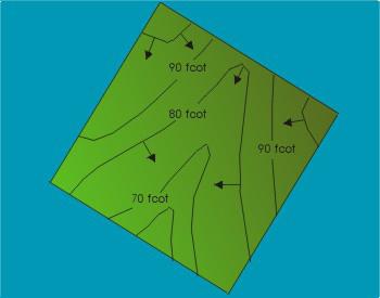
Relief depiction on plans and maps.
To solve engineering problems, the relief image must provide: firstly, a quick determination with the required accuracy of the heights of terrain points, the direction of the steepness of the slopes and the slopes of the lines; secondly, a visual representation of the actual landscape of the area.
The terrain on plans and maps is depicted in various ways (hatching, dotted lines, colored plastic), but most often using contour lines (isohypses), numerical marks and symbols.
A curved line connecting all points of the terrain with equal elevations is called horizontal.
When solving a number of engineering problems, it is necessary to know the properties of contours:
1. All terrain points lying on the horizontal have equal elevations.
2. Horizontal lines cannot intersect on the plan, since they lie at different heights. Exceptions are possible in mountainous areas, when horizontal lines represent an overhanging cliff.
3. Horizontal lines are continuous lines. Horizontal lines interrupted at the frame of the plan are closed outside the plan.
4. The distance between horizontal cutting planes is called relief section height and is designated by the letter h.
5. The distance between adjacent contour lines on a plan or map is called laying down the slope or slope.
Another characteristic of steepness is slope i. The slope of the terrain line is the ratio of the elevation to the horizontal distance. Slope is a dimensionless quantity.
The relief is made up of positive(convex) and negative(concave) shapes. The largest negative landforms on Earth are ocean basins, while positive ones are continents. These are first order landforms. Landforms of the second order are mountains and plains (both on land and at the bottom of the oceans). The surface of the mountains and plains has a complex topography consisting of smaller forms.
Morphological structures- large elements of the relief of land, the bottom of oceans and seas, the leading role in the formation of which belongs to endogenous processes . The largest irregularities in the Earth's surface form continental protrusions and ocean trenches. The largest elements of land relief are flat-platform and mountainous areas.
Plain-platform areas include the flat parts of ancient and young platforms and occupy about 64% of the land area. Among the flat-platform areas there are low, with absolute heights of 100-300 m (East European, West Siberian, Turanian, North American plains), and high, raised by recent crustal movements to a height of 400-1000 m (Central Siberian Plateau, African-Arabian, Hindustan, significant parts of the Australian and South American plain regions).
Mountain areas occupy about 36% of the land area.
The underwater edge of the continent(about 14% of the Earth's surface) includes a generally shallow flat strip of continental shallows (shelf), a continental slope and a continental foot located at depths from 2500 to 6000 m. The continental slope and continental foot separate the continental protrusions, formed by the combination of land and shelf, from the main part of the ocean floor, called the ocean floor.
Island arc zone- ocean floor transition zone . The ocean floor itself (about 40% of the Earth's surface) is mostly occupied by deep-sea (average depth 3-4 thousand m) plains, which correspond to oceanic platforms.
Relief of the ocean floor
| Zone | Characteristics |
| Shelf | The underwater margin of the continents has a common geological structure with the coastal land, the total area is up to 10% of the area of the World Ocean. Rich in minerals (oil, gas, diamonds, placer metals). |
| continental slope | Distributed from the lower shelf limit to depths of 2000 m or more; within its limits the granite layer decreases; has steep slopes, stepped, dissected by faults. |
| ocean bed | Occupies 70% of the area of the World Ocean, is located at a depth of an average of 6000 m, the earth's crust is of ocean type, complex terrain; ferromanganese nodules. |
| Mid-ocean ridges | Volcanic origin; at the boundaries of lithospheric plates; uplift of the oceanic crust consisting of basalts; along the axis of the ridges there is a deep fault - a rift zone where magma outflows; characterized by earthquakes and volcanoes. |
Morphosculptures- elements of the relief of the earth's surface, in the formation of which the leading role belongs to exogenous processes .
The work of rivers and temporary streams plays the greatest role in the formation of morphosculptures. They create widespread fluvial(erosive and accumulative) forms(river valleys, ravines, ravines, etc.). Glacial forms are widespread, caused by the activity of modern and ancient glaciers, especially the cover type (northern part of Eurasia and North America). They are represented by trough valleys, “ram’s foreheads” and “curly” rocks, moraine ridges, eskers, etc. In the vast territories of Asia and North America, where permafrost rock strata are common, various forms of frozen (cryogenic) relief are developed.
The most important landforms
The largest landforms are continental ridges and ocean basins. Their distribution depends on the presence of a granite layer in the earth's crust.
Continents and oceans - main landforms of the Earth. Their formation is due to tectonic, cosmic and planetary processes.
Mainland- This is the largest massif of the earth's crust, which has a three-layer structure. Most of its surface protrudes above the level of the World Ocean. In the modern geological era there are 6 continents: Eurasia, Africa, North And South America, Australia And Antarctica. Their areas are respectively 54, 30, 24, 18, 17, 9, 14 million km2.
World ocean- a continuous water shell of the Earth surrounding the continents and having a common salt composition. The world's oceans are divided by continents into 4 oceans: Pacific, Atlantic, Indian And Arctic.
The Earth's surface is 510 million km2. Land accounts for only 29% of the Earth's area. Everything else is the World Ocean, i.e. 71%.
Mountains and plains, as well as continents and oceans, are the main landforms of the Earth, as well as the main landforms. Mountains are formed as a result of tectonic uplifts, and plains are formed as a result of the destruction of mountains.
Approximately 60% of the land area is plains- vast areas of the earth's surface with relatively small (up to 200 m) fluctuations in heights.
Plains - vast areas of the earth's surface with small variations in elevation and slight slopes.
Plains– large areas with a relatively flat surface. Based on absolute height, plains are divided into lowlands (height 0-200 m), hills (200-500 m) and plateaus (above 500 m).
Example lowlands (from 0 to 200 m) can serve Amazonian lowland- the largest on Earth, and also Indo-Ghana lowland. It happens that lowlands are located below sea level - this is depressions . Caspian lowland located 28 meters below sea level. An example of a plain itself is the largest Eastern European plain.
At altitudes of 200-500 m above sea level there are hills . For example, Central Russian, Privolzhskaya, and above 500 m – plateaus And highlands . The largest of them are Central Siberian, Brazilian, Deccan, Guiana, East African, Great Basin, Arabian.
According to the nature of the surface - flat, hilly, stepped.
By origin:
Alluvial (accumulative) formed as a result of deposition and accumulation of river sediments (Amazonian, La Plata).
Denudation formed as a result of long-term destruction of mountains (Kazakh small hills).
Marine formed along the coasts of seas and oceans as a result of the retreat of the sea (Black Sea).
Mainland accumulative formed at the foot of the mountains by the accumulation and deposition of rock destruction products brought by water flows.
Water-glacial formed as a result of glacier activity (Meshchera,
Polesie).
Abrasion formed as a result of the destruction of coastlines by wave action of the sea.
Reservoir formed on platforms and are composed of layers of sedimentary cover (64% of all plains on the continents).
Mountains- elevations of the earth's surface (more than 200 m) with clearly defined slopes, base, and top. Based on their appearance, mountains are divided into mountain ranges, chains, ridges and mountainous countries.
Mountains(mountainous countries) - vast, highly elevated above the surrounding area, strongly and deeply dissected areas of the earth's crust with a folded or folded-block structure.
Mountains- areas of the earth's surface that are significantly elevated above sea level to a height of more than 500 m and are strongly dissected.
Mountains count low , if their height is from 500 to 1000 m; average – from 1000 to 2000 m and high – over 2000 m. The highest mountain peak on Earth is Mt. Chomolungma (Everest) V Himalayas has an altitude of 8848 m.
Free-standing mountains are rare, representing either volcanoes or the remains of ancient destroyed mountains. The morphological elements of mountains are: base, or sole; slopes; peak or ridge (at ridges).
Foot of the mountain- this is the border between its slopes and the surrounding area, and it is expressed quite clearly. With a gradual transition from the plain to the mountains, a strip is distinguished, which is called the foothills.
Slopes occupy most of the mountain surface and are extremely varied in appearance and steepness.
Vertex- the highest point of a mountain (mountain ranges), the pointed peak of a mountain - peak .
Mountain countries (mountain systems)- large mountain structures that consist of mountain ranges - linearly elongated mountain uplifts intersecting slopes. The points of connection and intersection of mountain ranges form mountain nodes. These are usually the highest parts of mountainous countries. The depression between two mountain ranges is called a mountain valley.
Highlands- areas of mountainous countries, consisting of heavily destroyed ridges and high plains covered with destruction products.
You can determine the height of mountains from a physical map using an altitude scale.
Mountains are divided by absolute height into:
Low (low mountains)- up to 1000 m (Tian Shan, Middle Urals).
Mid-height - up to 2000 m (Khibiny, Carpathians).
High (highlands) - more than 2000 m (Pamir, Himalayas, Andes).
Based on their structure, folded, folded-block and block mountains are distinguished.
Based on their geomorphological age, they distinguish between young, rejuvenated and revived mountains. Mountains of tectonic origin predominate on land, while mountains of volcanic origin predominate in the oceans.
Mountains differ not only in height, but also in shape. A group of mountains stretched out in a chain is called mountain range . For example, mountains have this shape. Caucasus. There are more mountain belts , For example, Alpine-Himalayan, And mountainous countries , For example, Pamir.
Mountains and plains are located both on continents and in oceans.
Based on their origin, mountains are divided into tectonic and volcanic.
Tectonic, in turn, are divided into:
Folded:“young”, formed during the Alpine folding (individual areas in the Himalayas) - “primary”.
Fold-block: with repeated tectonic movements in place of destroyed mountains - “revived” (Tien Shan, Altai, Transbaikalia).
Block-folded: The mountains, not completely destroyed by Mesozoic folding, are again raised by the latest tectonic movements - “rejuvenated” (Rocky Mountains, Tibetan highlands, Verkhoyansk Range).
Volcanic ones formed at fault lines or at the boundaries of lithospheric plates, composed of products of volcanic eruptions (Klyuchevskaya Sopka, Elbrus).
Largest mountain systems
| Name of the mountains | Max height (m) |
| Eurasia | |
| Altai | 4506(Belukha) |
| Alps | 4807 (Mont Blanc) |
| Himalayas | 8848 (Qomolungma) |
| Greater Caucasus | 5642 (Elbrus) |
| Carpathians | 2655(Gerlachowski-Stit) |
| Pamir | 7495 (Communism Peak) |
| Tien Shan | 7439 (Pobeda Peak) |
| Scandinavian | 2469 (Galchepiggen) |
| Africa | |
| Atlasian | 4165(Jebel Toubkal) |
| Kilimanjaro | 5895 (Kilimanjaro) |
| North and South America | |
| Appalachia | 2037 (Mitchell) |
| Andes (South America) | 6990 (Aconcagua) |
| Cordillera | 6193 (McKinley) |
| Rocky | 4399 (Elbert) |
| Australia | |
| Australia Alps | 2230 (Kosciuszko) |
| South Alps (N.Green) | 3756 (Kuka) |
The sizes of relief forms reflect the characteristics of their origin. Thus, the largest landforms are tectonic – were formed as a result of the predominant influence of the internal forces of the Earth. Forms of small and medium scales were formed with the predominant participation of external forces ( erosive forms).